

We speak of the Abagusii (the Kisii people), the Abakuria, the Abasimbiti, the Ngurimi and the Abasweta as separate tribes. The people themselves, and the historians who recorded their elders in the 1970s, tell a different story. In their accounts these are clans of one community that moved together, lived together and only later drifted into the groups we name today.
This article is a written version of a presentation I prepared for a working group of Mara Bantu researchers from across the world. It brings together a history of the Kipsigis, a history of the Abakuria, a colonial ethnography, an 1870 caravan route, oral interviews and our own fieldwork, and it maps them. Some of it is documented history. Some of it is hypothesis. I label which is which, because the strong evidence should not be dismissed along with the speculative parts.
In brief: the origin of the Abagusii and Abakuria#
The Abagusii (Kisii people) and Abakuria remember coming from Misri, a dry land north of Mount Elgon. With the Logoli and Suba they reached Yimbo on Lake Victoria around 1500, then the Kano plains, and by the 1700s they were living together at Gutura, south of today's Kisii highlands. Maasai raids between about 1774 and 1830 scattered them, and only then did "Gusii" and "Kuria" harden into separate names. Their closest kin are the other Mara Bantu of Kenya and Tanzania: the Zanaki, Ikoma, Ngoreme (Ngurimi), Nata, Isenye, Simbiti, Sweta and Ikizu, who speak closely related languages. The Abagusii also left clans among the Kipsigis of Bureti and Sotik. The rest of this article shows the evidence for each step.
How to read the evidence#
Every claim below carries one of four labels:
| Label | What it means |
|---|---|
| Documented | Written records, archaeology, dated sites, published scholarship |
| Recorded tradition | Oral traditions collected and published by historians |
| Place-name inference | Our reading of names in Ekegusii or Ekekuria. Suggestive, never proof on its own |
| Hypothesis | A new interpretation we propose, with what would confirm or refute it |
The main sources are T. Wakefield's Routes of Native Caravans (1870), C. W. Hobley's Eastern Uganda: An Ethnological Survey (1902), W. R. Ochieng's "Misri Legends in East and Central Africa" (1972), Henry Mwanzi's A History of the Kipsigis (1977), Paul Asaka Abuso's A Traditional History of the Abakuria c. A.D. 1400–1914 (1980), Herman Kiriama's "My Roots" (1986), a 1995 interview with the Ngoreme elder Mwita Maro, and Brett Shadle's study of the Mumbo movement (2002). Full references are at the end.
Names worn by one people#
The earliest written names for the Abagusii are outsiders' names. In 1870 a coastal caravan informant, Sadi bin Ahedi, called them Wa-Kosova. Hobley in 1902 wrote "Kossova or Kisii" and noted that "Kisii is their own name for their country". Kosova is popularly derived from the Ekegusii inka sobo, "our home".
The community also remembers a name for itself: Mwanyagetinge, the people of the getinge, the heavy coiled brass and iron rings worn on arms and legs as a mark of identity. The archival photographs show them clearly.
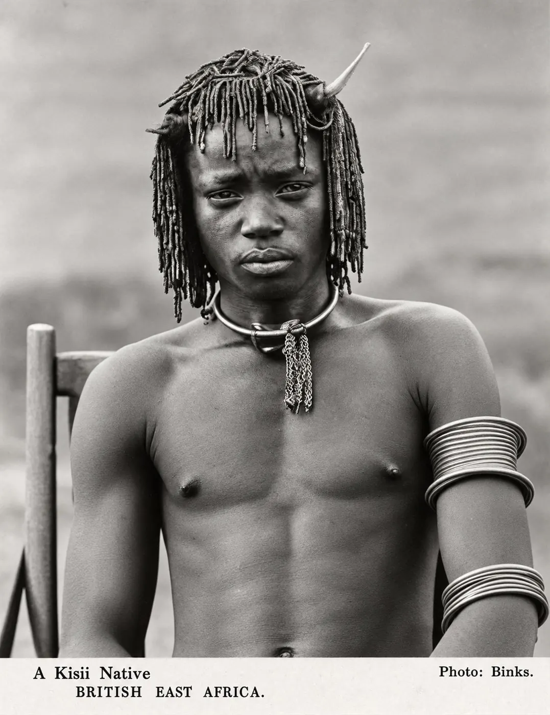
"A Kisii Native", photographed by Binks, early 20th century (digitally enhanced).
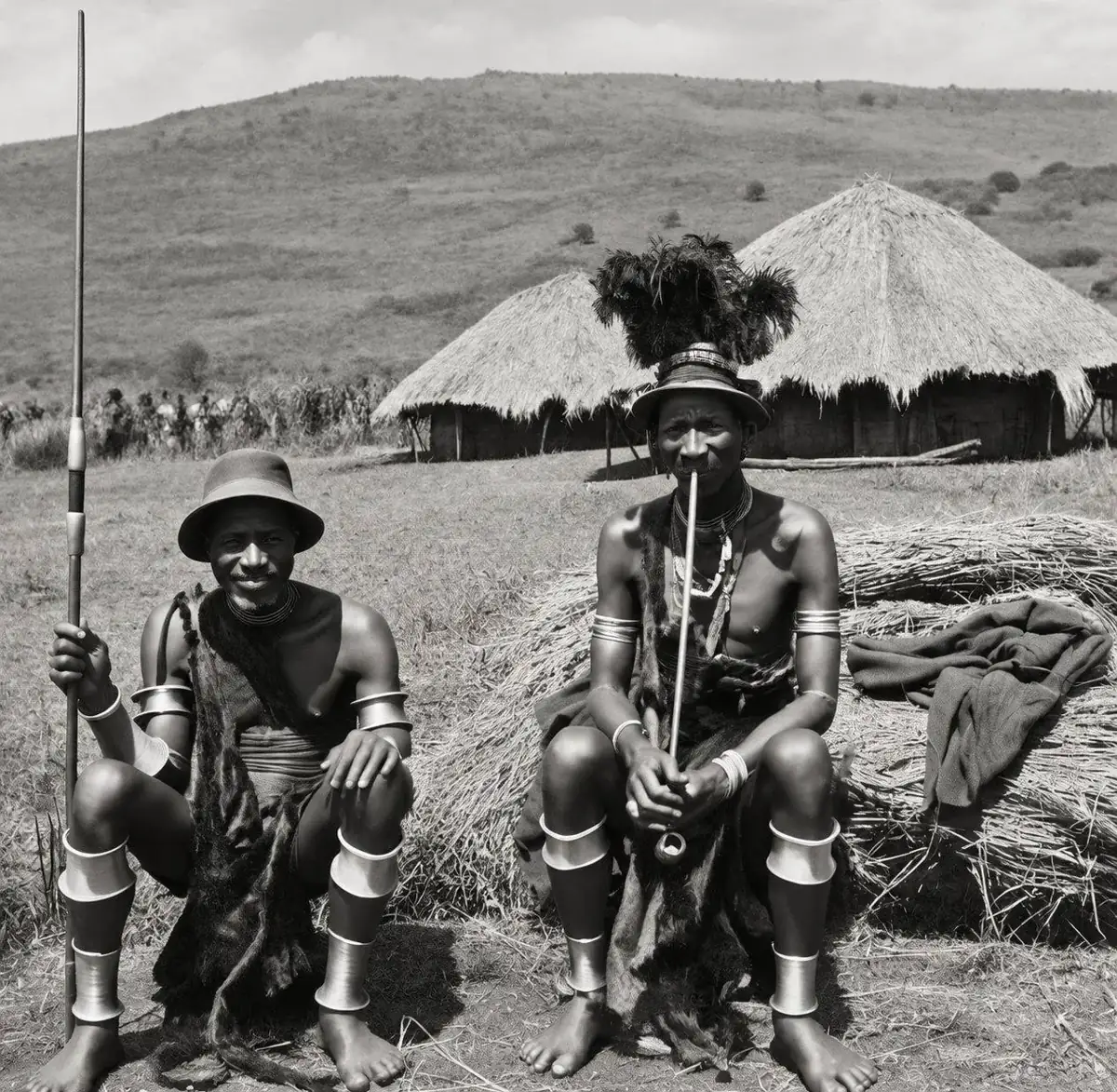
Gusii elders with stacked arm and leg rings (archival, digitally enhanced).
A question I would like answered: do Kuria, Simbiti and Ngoreme elders remember the same rings, and a related name? If so, that is a shared material marker across the "tribes".
The 1870 caravan route#
Sadi bin Ahedi's route ran Naivasha → Mau → Lumbwa → Kosova → Kaverond → Nandi. The Kosova were the next stage after Lumbwa, which is Kericho. (Documented.)
The inhabitants are called Wa-Kosova. They cultivate the soil, but have also plenty of cattle … Each man carries four spears … The shields these people carry are very large, larger even than those of the Masai.
In other words, the "Kosova" of 1870 sat on what is now the Kipsigis side, exactly where the Kipsigis historian places a Gusii population in the nineteenth century. Of the next stage, Kaverond, the informant said they "are the same as the Wa-Kosova, only a different clan. The language is one."
The origin of the Abagusii and Abakuria: "We came from Misri"#
Most textbooks trace Bantu speakers back to the Cameroon–Nigeria borderlands and bring the eastern stream to the Great Lakes around the Congo forest. The communities' own memory points somewhere else: north, to a dry land called Misri. (Recorded tradition.)
Gusii elders told Ochieng that Misri lay north of Mount Elgon, a dry country of drought and famine. From there they travelled south with the Kuria, Logoli, Bukusu, Suba, Kikuyu, Embu, Kamba and Meru, separating around Elgon "due to overcrowding, epidemics and drought". The Kuria (Abasonga) say their ancestor Mokuria lived in Misiri "near a large lake in a dry area" with the ancestors of the Gusii and Kikuyu. The Logoli, Bukusu, Tiriki, Samia, Haya, Kipsigis, Marakwet and Tugen tell similar stories.
Ochieng's sharpest observation is that Bantu and Nilotic peoples who share no language use the same word for this homeland. That makes Misri look like a remembered place, not just a direction.
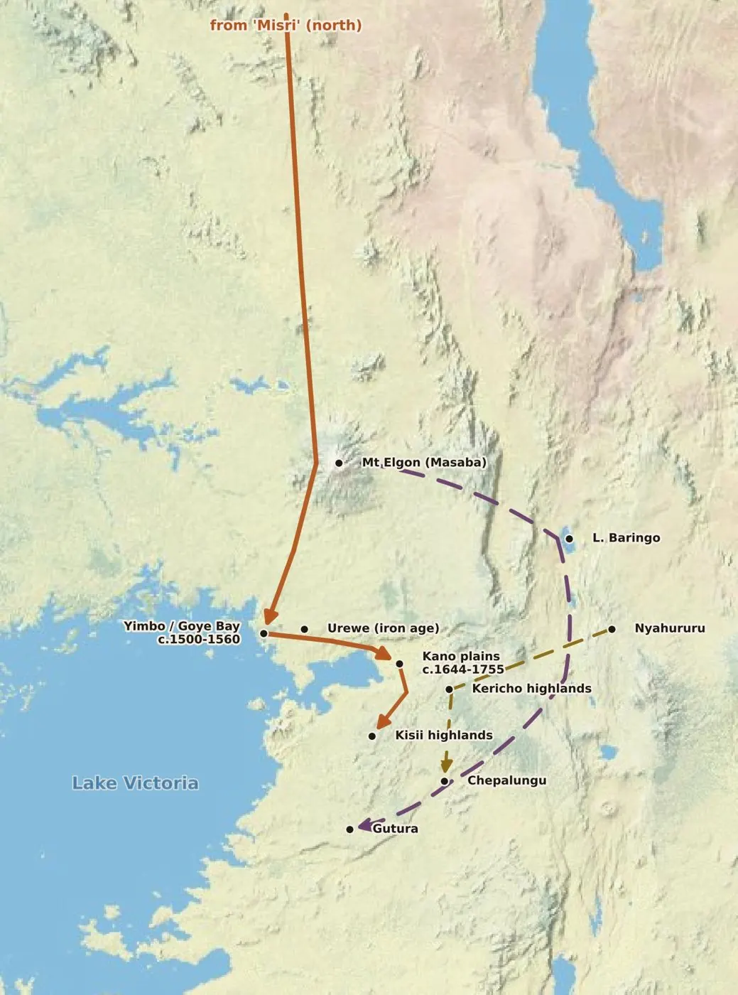
Three remembered roads south, all converging on Chepalungu and Gutura. Sources: Abuso pp. 37–40, 80–81, 94; Ochieng 1972. Basemap © Esri.
Historians have read the legend three ways:
| Reading | Who | Argument |
|---|---|---|
| Reject | G. A. Anyona, G. S. Were | Old Testament stories absorbed by Christianised elders; Misri may be dry Karamoja or Turkana |
| Keep open | B. E. Kipkorir, W. R. Ochieng | "Cannot be dismissed out of hand"; most tellers were non-literate elders with no church contact |
| Accept literally | J. Osogo, C. Luck | These peoples once lived near the Upper Nile and mixed with refugees from Egypt |
Ochieng's counter-question to the rejection camp still stands: if the Bible were the source, "why don't they say, straightaway, that they came from Bethlehem, Jerusalem, or Galilee?"
A chronology from generations#
Abuso dates Kuria history by counting generation-sets of roughly 28 years. Each date below is give or take a generation, but the shape is clear. (Recorded tradition.)
| Date (c.) | Event |
|---|---|
| 1400 | Conjectural start of Kuria society |
| 1500–1560 | Gusii–Kuria–Logoli–Suba cluster reaches Yimbo in Siaya |
| 1578–1662 | Abagumbe (the Kuria core) reach Gutura "from Chepalungu forest" |
| 1638 | Earliest ancestor in Kiriama's Gusii genealogy |
| 1644–1755 | Gusii on the Kano plains, where the totemic clans take shape |
| 1690–1802 | Gusii and Kuria live together at Gutura |
| 1718–1774 | Separation at Manga |
| 1774–1830 | Maasai attacks scatter Gusii into Kuria, Suna and Luo lands |
| 1830–1858 | Gusii consolidate in the present highlands |
| c. 1890 | Battle of Mogori: Gusii, Kuria and Luo defeat Kipsigis and Nandi |
Roughly three centuries of shared movement, then fifty years of Maasai pressure that scatter everyone, then consolidation into the groups we know.
What the sources say about one people#
Gutura#
Abuso's Kuria informants are direct:
All Kuria clans which stayed at Gutura were with them, the Gusii, for the Gusii were also staying there.
They separated, the texts say, because of famine, disease, Maasai raids, witchcraft accusations and overcrowding, not because of different ancestry. Abuso's own conclusion is that the Gusii and Kuria at Gutura "were probably one community with very little distinction between them", and he warns historians against "imposing the present outlook on that of the past".
There is a lovely detail anyone can check in their own family. At Kiribo the Kuria Abairegi were called Boke and the Gusii Nyaboke. Girls born near a river were named Kemunto, those born after a crossing Kwamboka, and those born just before one Kerubo. Both communities still use these names. They are a record of the same journey carried in two naming systems.
Bureti and Sot: the "upper Kisii"#
The strongest single piece of evidence comes from a history of the Kipsigis, not of the Gusii. Mwanzi reports that Bureti was "virtually a Gusii speaking area" by the middle of the nineteenth century, and that Bureti and Sot were remembered as the names of famous Gusii individuals. (Recorded tradition.)
The people of Sot are just Gusii who learned the Kipsigis language.
Before the battle of Mogori around 1890, Kipsigis leaders are remembered saying that "the lower Kisii should face the upper Kisii", meaning Bureti and Sot. Kipsigis accounts of that battle, Mwanzi writes, give "the impression that what happened was a civil strife among people of the same ethnic group". Towett put it most bluntly: if the Kipsigis divided themselves back into their tribes of origin, "there would be no one else to be called a Kipsigis".
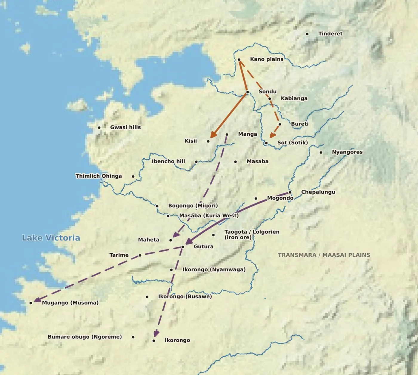
One corridor, two directions. Note the repeated names: several Ikorongo, and Masaba in both Kuria West and Nyamira. Rivers © OpenStreetMap; basemap © Esri.
The Sirikwa were Bantu#
The Kipsigis attribute stone enclosures and pit "dwellings" to an earlier people, the Sirikwa. Mwanzi weighs three theories about who they were. (Documented debate.)
| View | Proponents | Mwanzi's verdict |
|---|---|---|
| Maasai-speaking | Luck 1926; Jacobs | Rejected: the Maasai never built in stone, and only three informants said so |
| Kalenjin-speaking | Sutton | "Impressionistic": the Kalenjin say the Sirikwa were like them |
| Bantu (Kuria) | Dobbs 1918; Orchardson; Huntingford | "The bulk of the evidence": the Sirikwa were the modern Kuria, especially the Watende |
In 1918 C. M. Dobbs wrote that when the Sirikwa left Lumbwa country they "have gone across the Sondu river towards Kisii". The Kipsigis clans that claim Sirikwa descent all claim a connection with the Watende. "Sirikwa", Mwanzi suggests, simply means "those who went before us".
A warrior called Maina#
Hobley recorded an Okiek tradition that the Nandi and Kericho plateaux were once occupied by "Nyamwezi", which Mwanzi reads as a general Bantu presence, who left "crude dams … by a people who understood irrigation". A Kapchebokolwolek clan tradition from Bureti adds that one of the fierce Nyamwezi warriors was called Maina, "and this marks the beginning of Maina in Kipsigis country". (Recorded tradition.)
Maina was the first Kipsigis age-set in Belgut and Bureti, before about 1800. The Bukusu say they came from Misri "under the leadership of Maina". And Maina is a Kuria generation-set.
The same age-sets across "tribes"#
| Community | Age or generation-set names |
|---|---|
| Abakuria, Abasai family | Maina → Abasai → Nyambureti → Gamunyeri (a cycle of about 112 years) |
| Abakuria, Abachuma family | Chuma → Moirabe (Ngorongoro) → Gini → Nyangi |
| Kipsigis | Maina, Chuma, Sawe, Korongoro, Kaplelach, Kimnyige, Nyongi |
| Ngoreme (Mwita Maro) | Rikora Maina; Wasai, Gamunyeri; the Abanyambureti |
| Also shared | Gikuyu, Kamba, Embu, Meru, Bagishu, Bukusu |
One name stands out. A Kuria generation called Abanyambureti means "the people of Bureti", the district the Kipsigis call Gusii. (Place-name inference.)
A Ngoreme elder speaks#
In September 1995 the historian Jan Bender Shetler interviewed Mwita Maro, born in 1924 at Bumare, in the Serengeti district of Tanzania. (Recorded tradition.) He traced the Abamare from Soncho to Manyare, Mangwesi and Grumeti, and said the Abasweta "came from Tarime, from Kenya". He described obugo, stone forts on the hills built in the 1800s against the Maasai, "about three of them" still visible, beside sacred springs and pools in the rock where the clans sacrifice for rain and healing. And he said the "Wanyambureti" lived on those hills, with the Abamaina and Wasai, before moving down.
To be precise: the interview does not itself name Chepalungu or Nyangores. The Bureti connection is our inference from the name.
Gusii clans inside the Kipsigis and Nandi#
The Kipsigis plural suffix -ek hides Gusii names underneath. (Recorded tradition.)
| Kipsigis or Nandi clan | Gusii origin | What they contributed |
|---|---|---|
| Bakuserek | Abagusero | Ceremonial organisation, public worship |
| Baswetek, Kipaek | Abasweta | Rain-making |
| Kamoku | Gusii smiths | Iron-smelting; the Kipsigis' traditional blacksmiths |
| Kipiegen (Nandi) | Sweta, baboon totem engoge | The clan is still called ingoke |
| Mochorwek, Matoborik | Mochorwa; Watobori | Settlers of Bureti and Sot |
| Kaparangwek | Abarangi (North Mugirango) | Earliest settlers of Belgut, "real Kipsigis" |
Clans, not tribes#
Abagusii (Kisii people) clans#
By the time they left the Kano plains, Abuso (following Ochieng) says, the Gusii were already divided into totemic clans. (Recorded tradition.)
| Totem | Clans |
|---|---|
| Baboon, engoge | Abagetutu (Kitutu), Abanyaribari, Abamajoge and Abamachoge, including the Abasoti of Bomachoge Chache. Abuso notes the baboon clans "originally appear to have been one community known as the Abasweta" |
| Leopard, engo | Abagirango: South and North Mugirango, including the Abarangi |
| Zebra, enchage | Ababasi (Bobasi) |
| Hippopotamus, engubo | Abanchari, Abawanjare (Bonchari) |
Hobley's 1902 list of "Kossova" subdivisions includes Ugirango, Mugusero, Mowasi, Umachogi and, twice, Maina. Community tradition names Nyangore as father of the Abanyaribari, a name that echoes Nyangores in the Mau.
Abakuria clans, and the Gusii among them#
Abuso organises the Kuria into provinces (ikiaro): the Abagumbe (from Elgon, Baringo and Chepalungu, with a leopard totem taken from the Mugirango), the Abairegi (who lived with the Gusii at Kiribo), the Abanyabasi (Abaasi, Abapemba, Ababurati, Abasonga, Abamerani, with a zebra totem from a Gusii branch), the Abakira, and the southern Abamera, Abakenye and Abatimbaru.
Three communities inside Kuria society still recognise themselves as mainly Gusii in origin: the Abahirinyakegembe, the Abanchari (one people with the Wanjare, sharing the hippo totem) and the Abasweta, whom the Kuria call their "lost brothers".
The Abasweta: the baboon people everywhere#
If there is one pattern to remember, it is this. A single clan identity, Sweta with the baboon totem, appears among:
- the Gusii (Kitutu, Nyaribari, Majoge, Machoge)
- the Kuria (Abasweta, with age-sets)
- the Suna (Wasweta, who crossed by boat from Yimbo)
- the Kipsigis (Baswetek and Kipaek, the rain-makers)
- the Nandi (Kipiegen, "ingoke")
- the Ngoreme of Bumare ("from Tarime, Kenya")
Tradition makes Sweta a son of Suba and grandson of Girango, father or brother of the Gusii. This is exactly what one people split by later tribal labels would look like.
The Mara Bantu: Abagusii, Abakuria, Zanaki, Ikoma, Ngoreme, Nata and Simbiti#
Language is the most solid scientific support. Linguists classify the Mara Bantu languages as one sub-group of Great Lakes Bantu (Guthrie's zone E40: Gusii E42, Kuria E43, Zanaki E44, Nata E45, Sonjo E46). The family includes the Abagusii, Abakuria, Abasimbiti, Abahacha, Abasurwa, Abasweta, Abakiroba, Ngurimi (Ngoreme), Zanaki, Ikizu, Ikoma, Nata, Isenye and Sonjo. (Documented.) A cluster this tight usually implies a single speech community in the recent past, a few centuries rather than millennia, which matches the oral chronology.
Names that travelled#
Abuso noticed that these migrants carried place names with them: Nyandiwa, Sakwa, Gem and Masaba were all duplicated from north of the lake into South Nyanza, "a fairly common phenomenon with these people". The same logic runs through the clans. (Place-name inference.)
| Group name | Where it lives now | The land it remembers |
|---|---|---|
| Abasoti | Bomachoge Chache, Kisii | Sot (Sotik), "Gusii who learned Kipsigis" |
| Abanyambureti (generation) | Kuria; Ngoreme (Bumare) | Bureti, "a Gusii stronghold" |
| Ababurati (clan) | Abanyabasi, Bukuria | Bureti? (name resemblance) |
| Masaba | Kuria West; Nyamira; Kisii | Mount Elgon, "the north" |
| Nyandiwa, Sakwa, Gem | South Nyanza | Alego and Siaya, north of the lake |
| Abasweta of Bumare | Ngoreme, Tanzania | Tarime, Kenya |
Following the rivers out of the Mau#
From here on I move from what the books say to what we propose. (Hypothesis and place-name inference.)
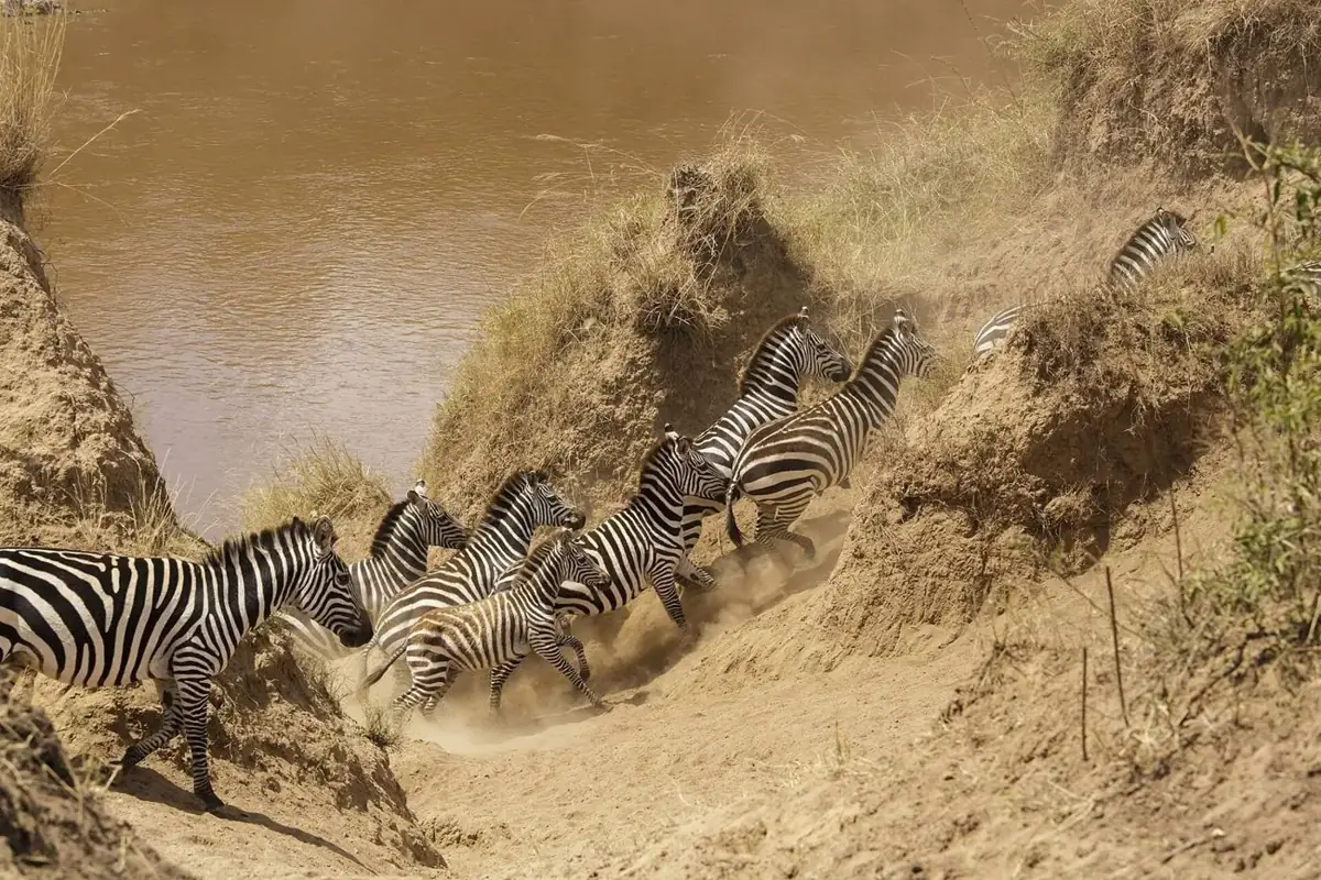
The Mara River. Photo: Thomas Fuhrmann, CC BY-SA 4.0.
The Nyangores and Mara rivers rise in the Mau forest; the Kiptiget and Itare feed the Sondu. These were the natural corridors for people leaving the forest, and the names along them read as Ekegusii and Ekekuria words.
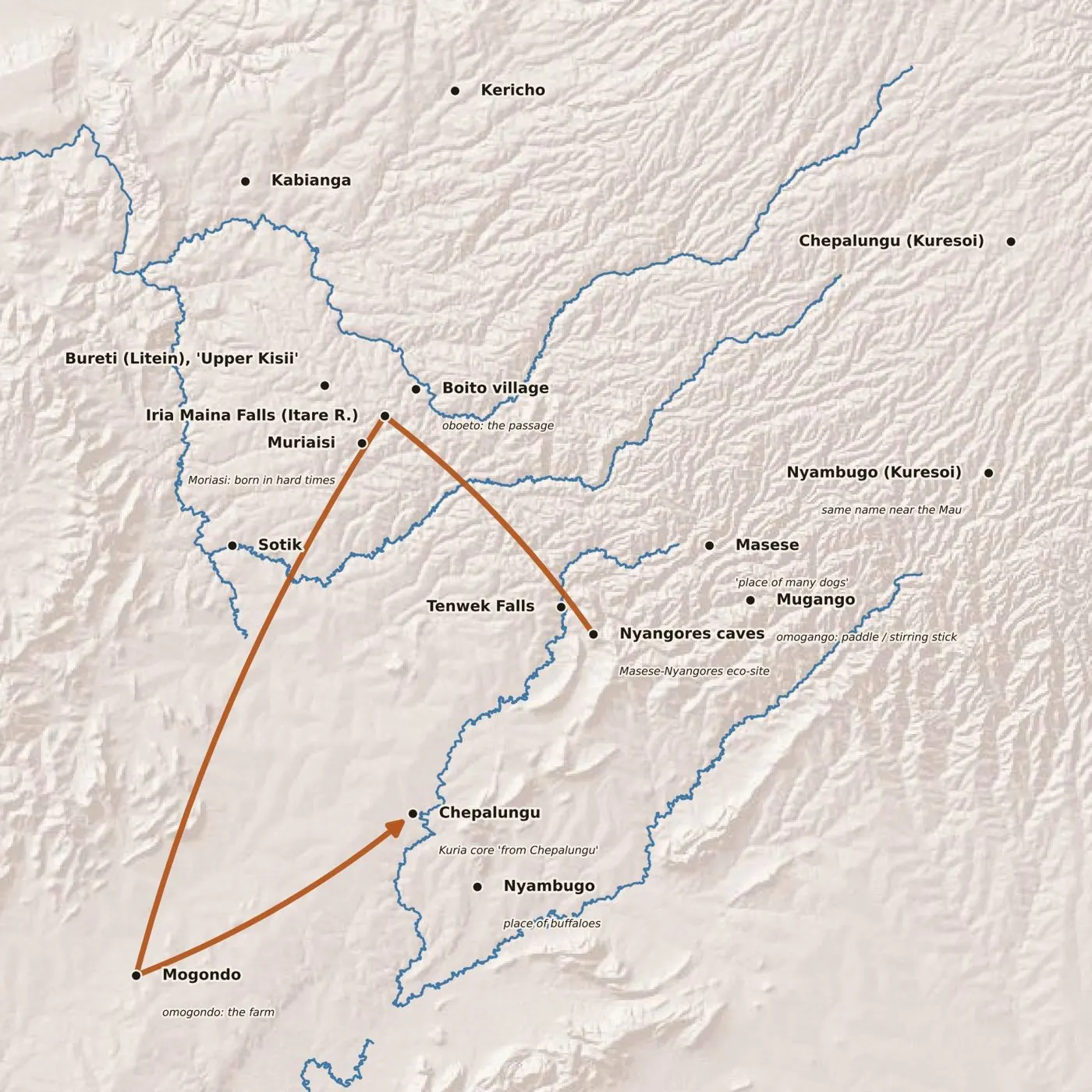
From the Nyangores caves to Chepalungu. Small-village positions are approximate and still to be GPS-verified. Rivers © OpenStreetMap; relief © Esri.
The proposed route:
- The Nyangores caves, beside villages called Masese and Mugango at the edge of the Mau. The Masese-Nyangores eco-site has caves on the path down to the river.
- Along the rivers to Iria Maina Falls, the rocky crossing on the Itare at Boito village, Konoin, about 6 km before Litein.
- Hard times at Muriaisi, and the passage at Boito on the other bank.
- Farms at Mogondo, in Transmara East.
- Chepalungu and Nyambugo. "From Chepalungu" is exactly where Abuso and Mwanzi say the Kuria core came from.
Reading the land in Ekegusii#
| Name | Where | Ekegusii or Ekekuria reading | Fits the story |
|---|---|---|---|
| Masese | By the Nyangores | Place of many dogs | A hunters' camp |
| Mugango | By the Nyangores | Omogango: a paddle or stirring stick | Cooking, settling |
| Itare | River that becomes the Sondu | Place of many rocks | A rocky crossing |
| Muriaisi | At Iria Maina | Moriasi: a child born in hard times | A hard departure |
| Boito | The opposite bank | Boeto: the passage, the way | The only crossing |
| Mogondo | Transmara East | Omogondo: a farm, a field | The first fields |
| Nyambugo | Chepalungu | Place of buffaloes | A hunting ground |
| Nyansara | An Eburi site by the Kuja | Place of arrows | Arrow-making |
These readings are mine and the group's. The test that makes them scholarly is to check each against Kipsigis and Maa etymologies. Where a Kalenjin speaker finds no meaning but a Gusii speaker finds an obvious one, the case grows much stronger.
Iria Maina: where the Maina age-set began?#
Iria Maina Falls is on the Itare River at Boito village, Itare Location, Konoin sub-county. A series of caves runs along the banks, one about 100 metres long with pools and rock pillars, and the site is known as a bat sanctuary. (Documented.)
Here is the hypothesis. Mwanzi records that the Maina age-set began in Bureti with a Bantu warrior named Maina. The falls carry his name, sit on the natural crossing, and the site museum shows artefacts that can be linked to the Abagusii and Abakuria. I believe the Maina age-set started here, and that the Kuria who left became the Abamaina, Abachuma and Abanyambureti. (Hypothesis.)
To be fair to the other side, tourism summaries say the caves were used by the Kipsigis for salt licks and gatherings. Later Kipsigis use does not rule out earlier Bantu occupation, but it has to be answered. Three pieces of fieldwork would settle a lot: photographing and cataloguing the museum objects, recording the falls' oral history in Kipsigis, and asking Kuria Abamaina, Abachuma and Abanyambureti elders whether their traditions point here. A county hydro-power project is planned at the falls, so the recording is urgent.
Stones, holes, iron and arrows#
Many places across Nyanza and northern Tanzania are called Eburi (Chiburi) or Ikorongo. My hypothesis is that these names mark one kind of site, built by one people, serving four purposes. (Hypothesis, built on recorded pieces.)
- Defence: stone walls and enclosures on hills, like the Ngoreme obugo.
- Water: holes and channels for irrigation, Hobley's "crude dams".
- Iron: smelting at places called Gutura or Gotura, with ore from Taogota (Lolgorien).
- Arrows: Nyansara, "the place of arrows", an Eburi site by the Kuja.
The written sources give each piece separately. Mwanzi gives the Sirikwa stone enclosures and pits; Hobley the dams; Abuso the iron ore at Taogota and the settlement at Gutura; Mwita Maro the hill forts with rock pools. The name pattern is our contribution.
A belt of dry-stone building#
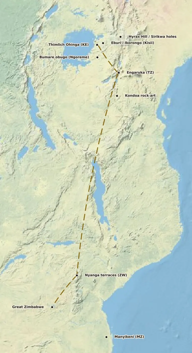
Sites documented; the connecting line is a hypothesis. Basemap © Esri.
| Site | Date (c.) | Type |
|---|---|---|
| Thimlich Ohinga, Migori | 15th–16th century | Dry-stone enclosures (UNESCO) |
| Eburi and Ikorongo, Kisii | Undated | Enclosures, holes |
| Bumare obugo, Ngoreme | 19th century (oral) | Hill forts, rock pools |
| Engaruka, northern Tanzania | 15th–18th century | Terraces, irrigation |
| Nyanga, Zimbabwe | 14th–19th century | Terraces, pit enclosures |
| Great Zimbabwe | 11th–15th century | Stone city (UNESCO) |
| Manyikeni, Mozambique | 13th–17th century | Zimbabwe-type enclosure |
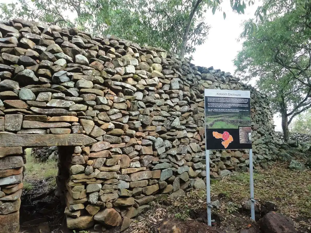
Thimlich Ohinga, Migori: walls up to 4 m high, over 500 years old. Photo: Wycondi, CC BY-SA 3.0.
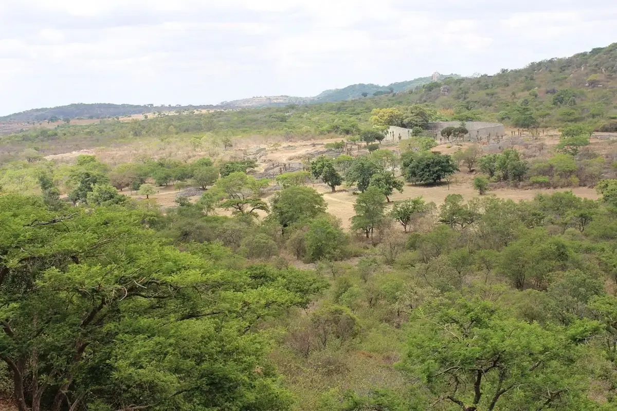
Great Zimbabwe, the Great Enclosure. Photo: Todinirunganga, CC BY-SA 4.0.
Two cautions. The dates overlap rather than running in a neat north-to-south sequence, which any connection hypothesis has to explain. And archaeologists do not attribute these sites to modern ethnic groups. Similar techniques can arise wherever stone is plentiful, so the real test is shared layout, dates and finds. Our own Eburi sites need to be photographed and dated; they are the missing middle of the comparison.
Iron#
Iron is where the record is firmest after language. (Recorded tradition and documented.) Mwanzi writes that "before this period iron smiths were people of Gusii descent", and names them: Kibiridi, Moito, Nyagide, Ngole, Meguni and Motito of the Kamoku clan, who taught the newcomers. Abuso records that Taogota was "famous for iron ore" that the Kuria went to collect. And beyond Lumbwa in 1870, the Wa-Likunono "are blacksmiths. They do nothing else but forge", selling spears, hoes and knives to their neighbours. Slag heaps and furnace remains at places called Gutura or Gotura would be easy to find, photograph and date.
Deeper time: four hypotheses#
Everything in this section is speculative. I include it because these are questions the group is asking and deserve to be tested, not asserted.
Out of the Sahara?#
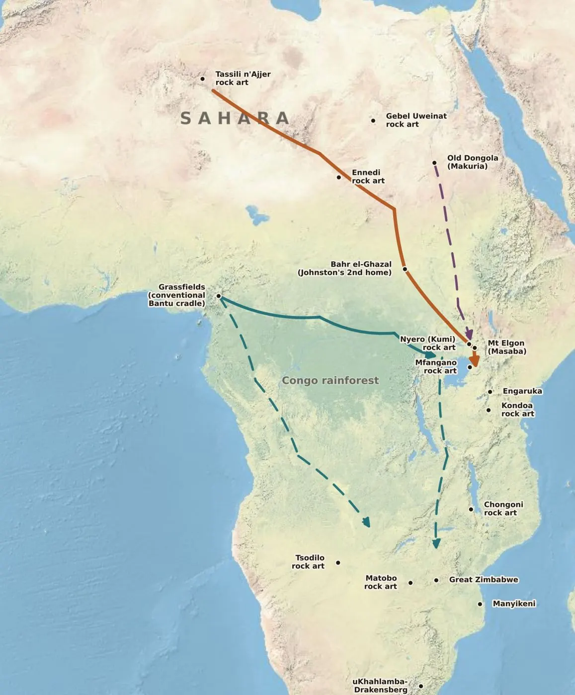
Competing models. Routes are schematic. Basemap © Esri.
The conventional model traces Bantu speech from the Cameroon–Nigeria borderlands some 3,000 to 5,000 years ago. Our hypothesis concerns population history, which can differ from language history: people can move, meet and adopt a language along the way. The idea is an earlier home in the green Sahara, with drying pushing people south-east through the Nile and Bahr el-Ghazal to Elgon. It is not as far-fetched as it sounds. Mwanzi cites Harry Johnston, who made Bahr el-Ghazal the "second home" of Bantu speech, and Jean Hiernaux, who placed the start of the Bantu movement into East Africa north of the Congo forest. The spread of the Bantu-associated Y-chromosome lineage E1b1a is often drawn along a similar path.
Rock art as waymarks?#
Africa's rock art runs from the Sahara south-east to the Great Lakes and on to southern Africa, the same pattern as that genetic spread. Mary Leakey called it "the greatest variety of rock art of any continent on earth and some of the oldest", and the Trust for African Rock Art maps the distribution.
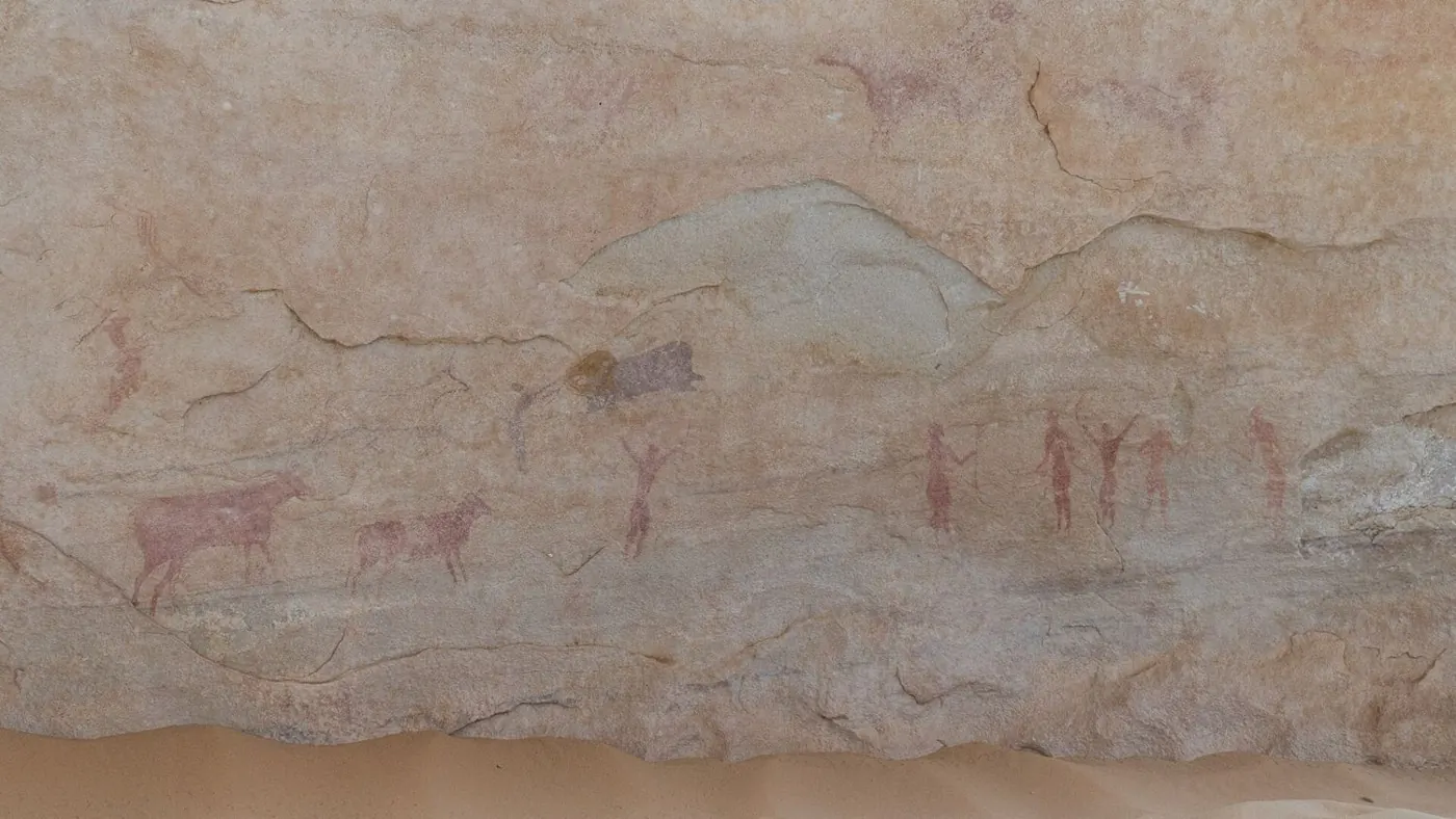
Tassili n'Ajjer, Algeria. Photo: IssamBarhoumi, CC BY-SA 4.0.
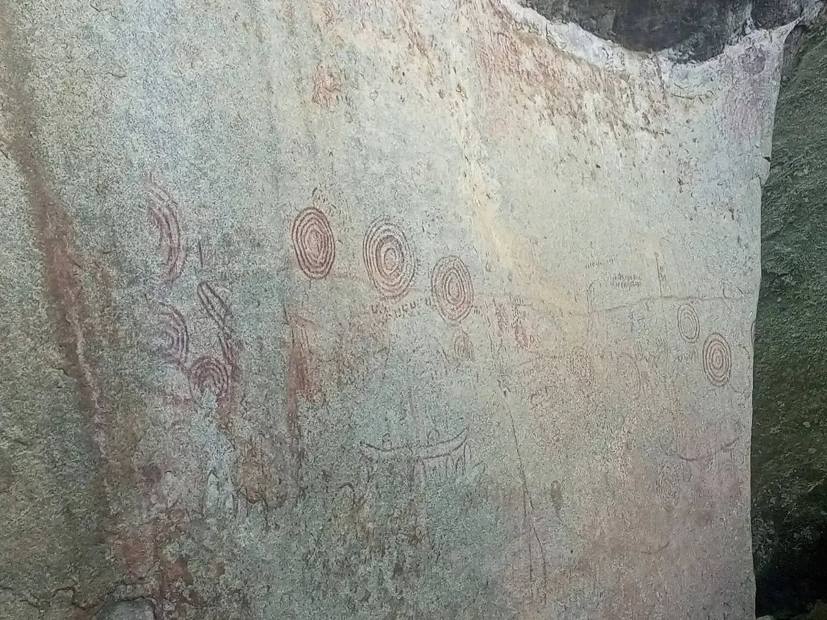
Nyero, Kumi District, Uganda, just west of Mount Elgon. Photo: Bonny.olobo, CC BY-SA 4.0.
Kondoa, Tanzania. Photo: Nina R, CC BY 2.0.
The hypothesis is that some painted animals served as markers, a way to trace the road back home. The difficulty is dating: much Saharan art predates the Bantu era by thousands of years, and specialists link many East African geometric paintings, Nyero's circles among them, to Twa and other hunter-gatherers. To be testable, the idea needs motif, date and location for each site along the route.
Makuria and the Kuria#
The name likeness is obvious: Makuria and Mokuria. So is a curious timing. Makuria was a Christian Nubian kingdom on the Nile, with its capital at Old Dongola, from about the sixth century until it collapsed in the late fourteenth under raids, plague and Mamluk pressure. Abuso's conjectural start of Kuria history is around 1400, within a lifetime or two.
One correction to a story often attached to this idea. The Nubian king who marched against the Assyrians when they besieged Jerusalem around 701 BCE was Taharqa ("Tirhakah, king of Ethiopia", 2 Kings 19:9), a ruler of Kush, based at Napata. That is some 1,200 years before Makuria existed. The Nubian reputation for archery is real and ancient (Egyptians called Nubia Ta-Seti, "the land of the bow"), but it belongs to Kush as much as to Makuria.
So the Makuria link is a coincidence worth testing, not yet a connection. Good tests would be Nubian or Arabic loanwords in Ekekuria, genetic comparisons with Nubian populations, and Christian or Nubian motifs in Kuria ritual.
Archers and soldiers#
Some of the Kuria martial reputation is on record: the Wa-Kosova's poisoned throwing spears and huge shields in 1870, the Gusii–Kuria–Luo alliance that routed the Kipsigis and Nandi at Mogori, and the conscription of Kuria men by both the Germans and the British in 1914. Other parts are widely told but still need a source. The claim that more than half of the force that removed Idi Amin in 1979 was Kuria is one I could not find in any written record. If it cannot be sourced, it should be recorded as veterans' testimony while those veterans are still with us.
The lost tribes, south of Abyssinia#
The ninth-century Jewish traveller Eldad ha-Dani placed tribes of Israel beyond the rivers of Cush, near the Sambation, a river of stones that rests only on the Sabbath. On old maps of Africa, the land south of Abyssinia is roughly where Bantu speakers live today. Ochieng also summarises C. Luck's argument that Israelite exiles in Egypt fled south after the Elephantine garrison mutiny in the seventh century BCE.
This needs care. Eldad's account is a medieval travel narrative, and colonial writers used ideas like this for the "Hamitic hypothesis", which credited African achievements to outsiders. The question here is the opposite one: whether the Mara Bantu preserve memories of real contact with the Nile world. It is a question about contact, never about worth.
Masaba: the mountain that became a direction#
This one is well documented. (Documented.) Mount Elgon is Masaba to the Bagisu, Bamasaba and Babukusu. Among the Luyia, G. S. Were showed, "Masaba" came to mean simply "the north". The Kuria Abagumbe call part of their land Masaba "to remind them of Mt Elgon", and today there is a Masaba ward in Kuria West and Masaba North and South in Nyamira and Kisii. The same name, used by communities now called different tribes, points back to the same mountain on the Misri road.
Religion and herbalism#
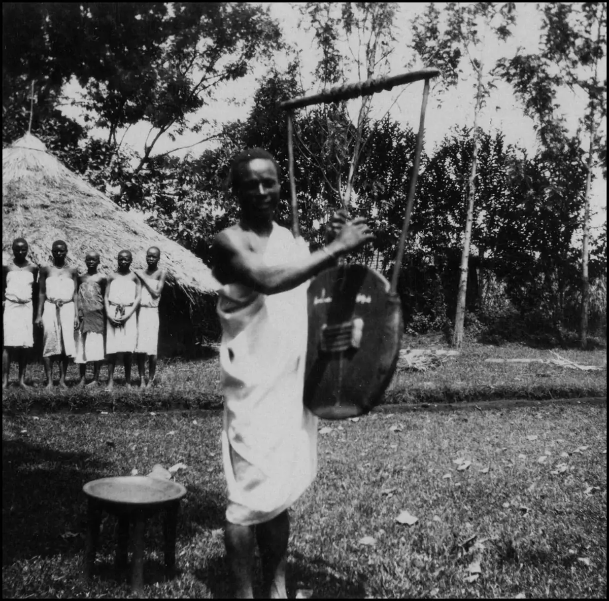
A Gusii man playing the obokano. Photo: Wikimedia Commons, CC0.
The religious structure is shared across the group: a distant high God, near ancestors, specialists who divine and heal, and sacred water.
- Abagusii: a supreme God, Engoro (also Nyasae, a Luo loanword), ancestral spirits, and diviners (omoragori).
- Abakuria: Nyanokwe (God), linked in tradition to the sun, Enokwe. This should be confirmed with Kuria elders.
- Ngoreme: emisambwa at rock springs. Each clan goes to its own spring or pool, starting at Sengere, and a white goat is killed for all the clans at Nyegekenye.
- Into the Kipsigis: public worship from the Bakuserek, and rain-making from the Baswetek.
Sakawa and the serpent Mumbo#
Brett Shadle's study of the Mumbo movement shows Gusii religion meeting colonial rule. (Documented.)
| Date | Event |
|---|---|
| 1890s | The Gusii prophet Sakawa foretells the coming of Europeans, and that an empty valley will become Kisii town |
| c. 1902 | Sakawa vanishes after a beer-drink; no body and no grave are found, and many believe he lives |
| 1913–1918 | The lake serpent Mumbo spreads from Alego; the Gusii adept Mochoronge teaches in Nyaribari; followers give 155 cattle by 1918 |
| 1920 | In Getutu, a woman named Bonairiri teaches Sakawa's return, and "practically the whole of Getutu went to her school". She is confined and four leaders are exiled to the coast |
Herbalism: a gap to fill#
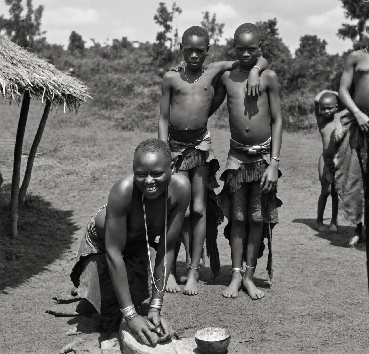
Archival photograph (digitally enhanced).
I have to be honest here: the written sources say almost nothing about herbal medicine. It appears only as the "mysterious dawa" of colonial reports, the diviners and rain-makers, and the Ngoreme springs visited "for sickness". That knowledge is held by elders and is disappearing fastest, which makes it the most urgent thing to record. A shared template would let people in Kenya, Tanzania and the diaspora contribute comparable entries: the plant's Ekegusii, Ekekuria, Kipsigis and botanical names; its use and preparation; where it grows; and the informant, clan, date and consent. Shared plant names across Gusii and Kuria would be yet more evidence of one people.
Where the evidence stands#
| Claim | Status | Key source |
|---|---|---|
| Gusii and Kuria lived as one community (Gutura, Manga) | Recorded tradition | Abuso |
| Bureti and Sot were Gusii until about 1900 | Recorded tradition | Mwanzi |
| The Kuria core came "from Chepalungu" | Recorded tradition | Abuso; Ogot |
| The Sirikwa were Bantu (Kuria) | Majority tradition | Mwanzi; Dobbs |
| Gusii, Kuria, Ngoreme, Zanaki and Nata form one language cluster | Documented | Linguistics |
| Sweta, Masaba, Bureti and Soti names carried between groups | Documented and inference | Abuso; fieldwork |
| The Nyangores → Iria Maina → Mogondo route | Hypothesis | Fieldwork |
| The Maina age-set began at Iria Maina | Hypothesis | Fieldwork; Mwanzi |
| Eburi and Ikorongo as one site type, linked to Thimlich and beyond | Hypothesis | Fieldwork |
| Saharan origin, rock-art waymarks, Makuria, Sambation | Speculative | To be tested |
The central argument does not depend on the speculative half. The top of the table rests on published historians and linguists. If every deep-time hypothesis failed tomorrow, the Abagusii, Abakuria and their neighbours would still look like what their elders said they were: one people, recently divided.
The next steps are practical: GPS every Eburi, Ikorongo and crossing; catalogue the Iria Maina museum; test each place name with Gusii, Kuria, Kipsigis and Maa speakers; record elders, with consent; read Ochieng's 1974 Gusii history and Ogot's History of the Southern Luo in full; and put every place, route and claim into a shared atlas, with its source and status, so that anyone can check the reasoning.
References#
- Abuso, P. A. (1980). A Traditional History of the Abakuria c. A.D. 1400–1914. Nairobi: Kenya Literature Bureau.
- Hobley, C. W. (1902). Eastern Uganda: An Ethnological Survey. London: Anthropological Institute.
- Kiriama, H. O. (1986). My Roots and Their Importance in Understanding Abagusii History. Transafrican Journal of History 15: 191–201.
- Mwanzi, H. A. (1977). A History of the Kipsigis. Nairobi: East African Literature Bureau.
- Ochieng', W. R. (1972). "Misri" Legends in East and Central Africa. East African Journal, October 1972.
- Ochieng', W. R. (1974). A Pre-Colonial History of the Gusii of Western Kenya. Nairobi: East African Literature Bureau.
- Shadle, B. L. (2002). Patronage, Millennialism and the Serpent God Mumbo in South-West Kenya, 1912–34. Africa 72(1): 29–54.
- Shetler, J. B. (1995). Interview with Mwita Maro, Maji Moto. Mara Cultural Heritage, Goshen College and MATRIX, Michigan State University.
- Wakefield, T. and Johnston, K. (1870). Routes of Native Caravans from the Coast to the Interior of Eastern Africa. Journal of the Royal Geographical Society 40: 303–339.
- Welsby, D. A. (2002). The Medieval Kingdoms of Nubia. London: British Museum Press.
- Iria Maina Falls, Abiri Kenya; "A sanctuary for bats in Bomet that pulls in tourists", Daily Nation.
- UNESCO World Heritage List: Thimlich Ohinga (1450), Great Zimbabwe (364), Kondoa Rock-Art Sites (1183), Tassili n'Ajjer (179). Trust for African Rock Art.
Maps drawn for this article on Esri basemaps, with rivers and place names © OpenStreetMap contributors (ODbL). Photographs from Wikimedia Commons as credited, and archival images of the Abagusii.